Illinois Archaeological Predictive Model (IAPM)
The Illinois Archaeological Predictive Model (IAPM) is a GIS-based tool developed by the Illinois State Archaeological Survey. The model builds on over a century of archaeological work in Illinois and considers the known locations of prehistoric Native American sites, landforms that lack archaeological sites, and other environmental and geophysical variables such as elevation, distance to rivers and streams, and native vegetation. Sampled data from these locations are analyzed via GIS (Geographic Information Systems) and fed into a TensorFlow neural network (a machine learning algorithm) to predict the probability of encountering an archaeological site in every two acre square (90 x 90 meter cells) across the state.
ISAS and other interested stakeholders use the IAPM to help protect, preserve, and assess the potential impact to irreplaceable and non-renewable archaeological resources within the context of Illinois' need to encourage and promote sustainable development. Archaeologists use the IAPM to help prioritize time and resources during surveys, and it allows us to make recommendations that prevent or mitigate impacts to the archaeological record. It also has the potential to enable ordinary residents, managers, developers, and preservationists to become proactive planners when it comes to the archaeological resources of Illinois.
Interested? Go to https://go.isas.illinois.edu/IAPM or click on the image below to explore the Illinois Archaeological Predictive Model web map. This is a free service offered by ISAS for landowners, developers, and fellow archaeologists. Please direct any questions or requests for additional information about the model to John Lambert.
Information about the IAPM presented in the web viewer is for planning purposes only and will have no bearing on the Illinois State Historic Preservation Office (SHPO) determination of whether archaeological survey will be required for any project or undertaking. Questions about survey requirements or consultation with the Illinois SHPO should be directed to the state’s Chief Archaeologist, Jeff Kruchten.
You can use the web map to explore the Illinois Archaeological Predictive Model.
- Navigate to your area of interest by clicking My Location, searching for an address or place, or entering a set of coordinates.
- Use the Layer List (stacked diamond icon) to turn the site probability layer or other layers on/off. Click the Legend to see symbology for all active layers.
- You can also use drawing tools, add spatial data for projects or other areas of interests, or print map layouts.
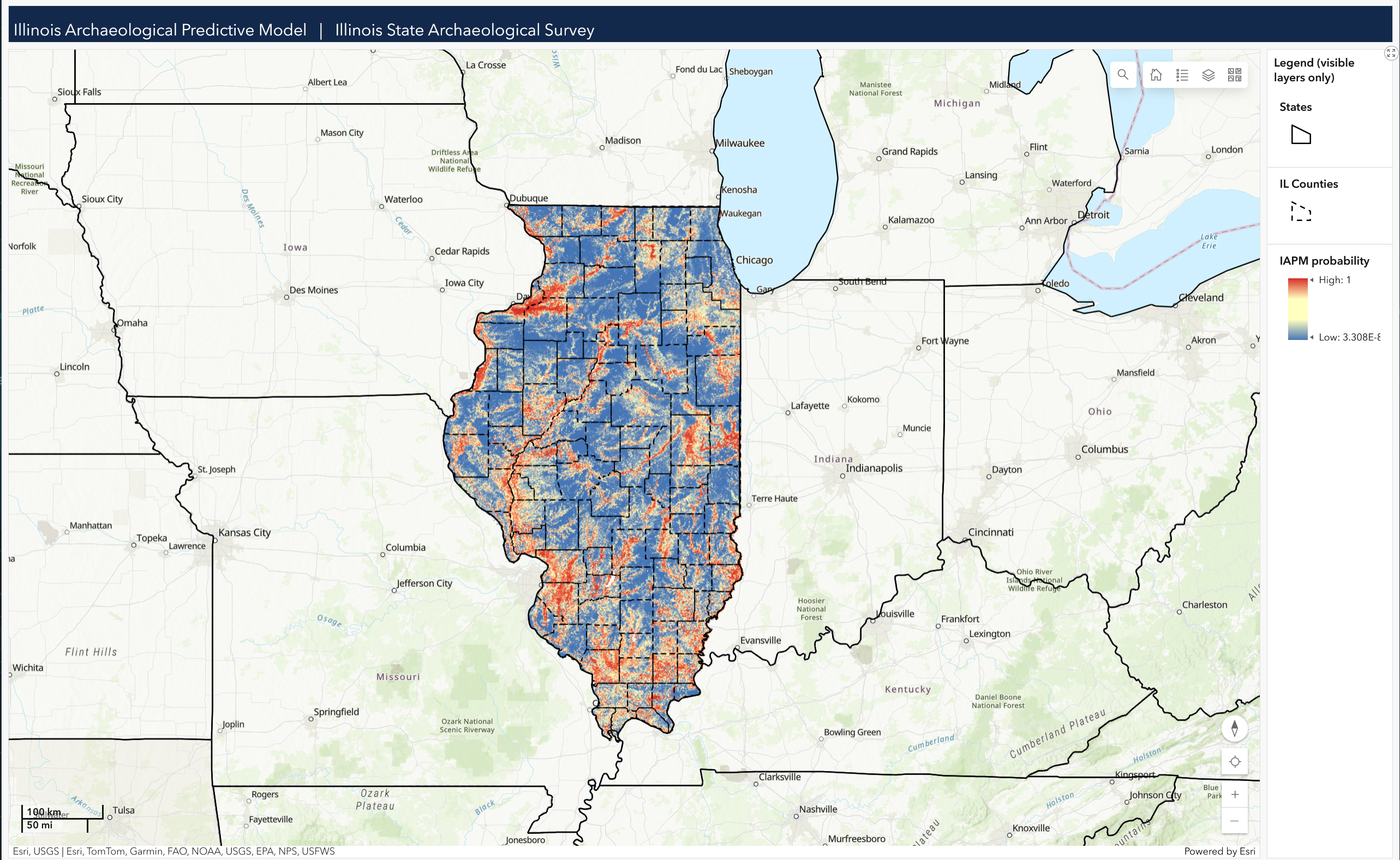
The Illinois Archaeological Predictive Model (IAPM) predicts the probability of encountering an archaeological site in each 90x90 m cell across the state. Probability values are on a continuous scale between 0.0 (blue) and 1.0 (red).
Data in the IAPM web viewer, including predicted site probability, predicted erosion hazard, and development intensity are distributed under a CC-BY-SA license (Attribution-ShareAlike 4.0) by the University of Illinois Board of Trustees, courtesy of the Illinois State Archaeological Survey.