Climate Change and Erosion Modeling

Climate Change and Erosion Modeling

Illinois’ Archaeological Record in Danger

Thousands of cultural sites from the pre-contact and historic eras, made up of house foundations, trash-filled storage pits, cooking hearths, and living surfaces are still preserved just below the surface across the state of Illinois. There were the homes of Indigenous Illinoisans and, more recently, historic-era Euroamericans, Black Americans, and others going back 13,000 years. Some of these sites are places where people made a living, and offer evidence that speaks to changes in the daily lives of the people that called this landscape home for millennia. Many are also sacred places of great value to descendant communities—mounds, burial grounds, and shrines—places where people modified the landscape in sometimes spectacular ways or imbued spaces with meaning by virtue of their ancestors and cultural objects they left behind.

These buried sites and artifacts represent the material record of past human behavior, and are an invaluable, non-replaceable resource for archaeologists trying to answer questions about how human groups adapted to (or sometimes created) changes in their physical and social environments. These sites also tether families and communities to landscapes, stories, and history more generally. However, this important and fragile record of unwritten human history is under threat of disappearing. The culprit? Climate change. In Illinois, factors like erosion and flooding are becoming increasingly common and intense, and threaten to erase much of our shared cultural heritage.

Today, 75% of Illinois is farmland, and for much of the last 200 years farmers cultivated their fields using plows that turned over the soil and left it— and the archaeological remains of thousands of habitation sites— exposed to melting winter snows and heavy spring rains. Conservation practices deployed since the 1970s like no-till agriculture, conservation tillage, and cover crops are now used on roughly half of Illinois farms and have helped to slow the rate of topsoil erosion, but they have not stopped it. The pace of erosion-induced landscape change is often subtle, with topsoil in farmers’ fields slowly, sometimes imperceptibly, degrading. But with the increasing severity of precipition events, the pace of erosion is accelerating. Record-breaking rains and flash floods can lead to staggering amounts of erosion during single events. The earth is washing away, a little (or sometimes a lot) at a time.

Large swaths of the state— those areas where the soil is easily eroded, where farm field slopes are particularly steep, and where there are many cultural sites of historic significance— are poised to suffer significant impacts in the coming decades (see examples in Figures 1-2). And with every fraction of an inch that washes downstream, the farmer‘s plow goes a little deeper. Year after year. And while farming is a major source of erosion in Illinois, it is obviously not the only one. Deforestation, loss of other habitat such as native prairies, and construction associated with development all play a role as well.

To better understand the threat to Illinois’ cultural heritage posed by climate change, the Illinois State Archaeological Survey (ISAS) has begun modeling which parts of the state are most vulnerable to increased topsoil erosion (Figure 3). In our map of predicted erosion potential for Illinois several areas stand out as particularly vulnerable, including the steep, intensively farmed slopes of western and northwestern Illinois and the more rugged terrain along the Kaskaskia and Embarras River drainages in the southern part of the state. However, zooming in to a smaller area (Figure 3 inset) shows that there is a lot of local variation—generally speaking, places with steep slopes that are under cultivation are more susceptible to erosion than places that are flatter or benefit from forest cover or other surfaces which hold topsoil in place. Even if nothing were to change, erosion poses a much more acute threat to buried archaeology in some parts of Illinois than others. Given current projections for climate change, these impacts will likely be accelerated, and many sites are likely to disappear in the coming years. In fact, 80% of pre-contact archaeological sites and 82% of historic sites lie in areas with high predicted erosion potential in our model.

emerald gully
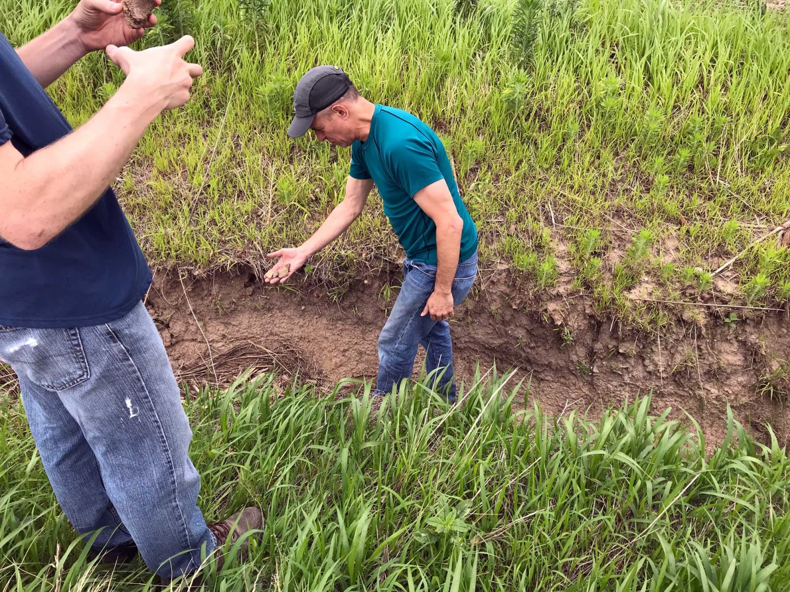
Figure 1. Large erosional gully at an archaeological site in St. Clair County, Illinois (click to enlarge image). Photo courtesy of Tim Pauketat.
emerald gully
Figure 2. Second view of the erosional gully at the same site. Potsherds and other artifacts are actively eroding out of the cutbank in the foreground. Archaeologists for scale. (click to enlarge image). Photo courtesy of Tim Pauketat.
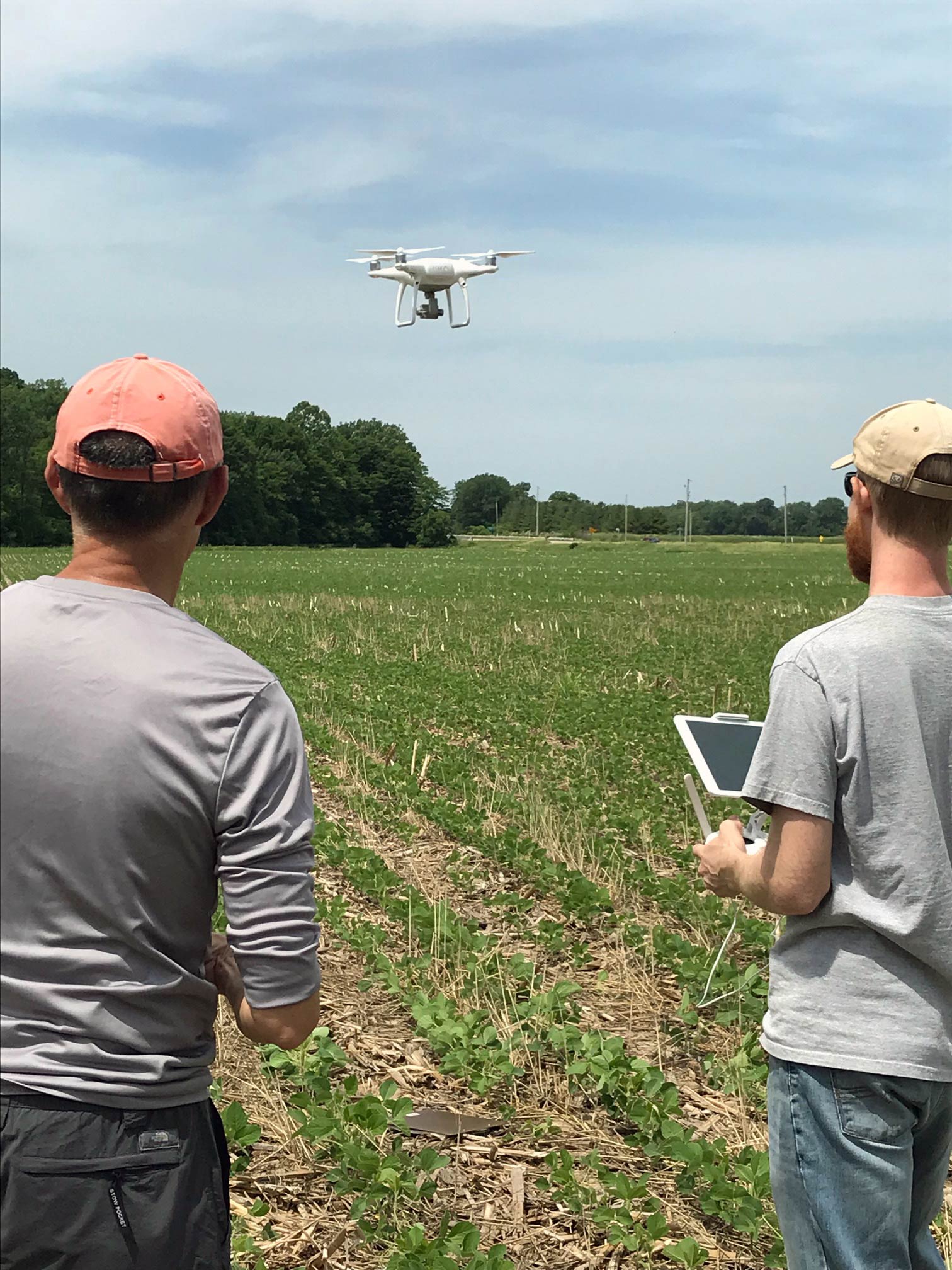
Our approach uses a modified version of the RUSLE, the Revised Universal Soil Loss Equation, to predict which areas are most likely to erode under current conditions (Figure 3). Establishing this baseline is an important first step, and the results can be modified to account for changes to precipitation, vegetation cover, or other factors which are likely to exacerbate erosion as climate change intensifies in the future. Our model uses several key variables:

  • Rainfall erosivity based on 10 years of monthly precipitation totals for Illinois. This measure takes into account both total precipitation during a year and how concentrated the distribution of rainfall is during particular months.
  • Soil erodibility, which is a property of individual soil types. Other things equal, some soil types are more or less resistant to erosion than others.
  • Slope length. Longer slopes allow water to reach higher velocities, which have greater erosive potential. This is based on statewide LiDAR elevation data for Illinois.
  • Slope steepness. Similarly, steeper slopes increase erosion because water moving down them has a chance to build more momentum.
  • Land cover type, which affects how much erosion is mitigated by different kinds of vegetation, crop cover, or urban development relative to bare ground.
RUSLE Erosion Index - Illinois map
Figure 3. Map showing the RUSLE erosion index for Illinois (red = high potential, green = low potential). Inset shows an example of local variation in the area southwest of Lake Shelbyville in south-central Illinois with portions of surrounding counties. (click to enlarge image).

The RUSLE model generally also includes the effect of soil conservation practices such as contour plowing, terracing, or planting of cover crops which help mitigate topsoil erosion. However, comprehensive data for where these topsoil conservations practices are actually currently in place do not exist for the state of Illinois.

Surface erosion is not the only hazard to our buried archaeological sites in Illinois. Flooding (Figure 4), which threatens to wash entire cultural sites downstream, is also projected to increase as annual precipitation and storm intensity rises. Archaeological sites are also frequently impacted by earth moving and erosion caused by urban development (Figure 5), here measured by the number of NPDES stormwater discharge permits for each ZIP code over the last 30 years. These permits are required for most construction projects that disturb one or more acres, and while they do not capture all development they make a good proxy we can use to measure how rapidly certain municipalities have grown. While it is difficult to predict exactly where future development is likely to take place in the state, it is likely that the impact of construction activities on archaeological sites will continue to increase as populations rise. These trends may only accelerate if Illinois becomes a destination for climate refugees fleeing other parts of the country. The layers for predicted erosion, FEMA flood risk, and development intensity shown in Figures 3-5 have also been added to ISAS’ publicly available IAPM web viewer, which allows users to compare predicted site probability to these potential hazards to the archaeological record.

FEMA Flood Hazard Map Illinois
Figure 4. FEMA flood hazard map for Illinois and adjoining states showing areas with a 1% annual flood chance (so-called 100 year floods), 0.2% annual flood chance (so-called 500 year floods), and floodways, as well as areas with minimal flood risk or reduced risk due to levee construction. (click to enlarge image).
Stormwater Development - Illinois
Figure 5. Total number of NPDES (National Pollutant Discharge Elimination System) storm water discharge permits for all Illinois ZIP codes for 1991-2020. (click to enlarge image).

Climate-change-induced loss of the state’s cultural heritage is a social justice issue that will be felt most acutely by low-income Illinois citizens and Tribal descendant communities who have traditionally been the most marginalized. Many live in the most vulnerable areas. Doing nothing in the face of this crisis is not only inaction. It is a conscious choice to let the tangible links to history disappear forever.

Given the scale of this challenge, what is the best way forward? The effects of erosion, flooding, and development are irreversible, and archaeological sites are not a renewable resource. Mitigating the effects of climate change on the archaeological record will involve hard choices about what to save and how to save it. Sadly, loss of cultural heritage is generally ignored as a priority in national and international efforts to combat climate change. However, there are some emerging efforts to protect archaeology in the United States from climate change— NAHAR (North American Heritage at Risk), the Society for Historic Archaeology’s HARC (Heritage at Risk Committee), and the Society for California Archaeology’s Climate Change and California Archaeology study, to name a few. The Society for American Archaeology statement on climate change (2022) acknowledges the scope of the problem, and pushes for it to be a more urgent priority for “archaeologists, community partners, relevant regulatory agencies, and local, state, and federal governments.” Most of these efforts are focused along the nation’s coastline, and Illinois and other parts of the Midwest are generally not represented.

If we are to change this state of affairs, we need more archaeological survey and modeling to obtain a more realistic picture of what is threatened. Large-scale mitigation will require planning, funding, and archaeological work at an unprecedented scale. Annual spending in the United States on Cultural Resource Management (CRM) is currently $1.46 billion, and is expected to grow to $1.85 billion by 2031. Even if we double or triple this number, the costs associated with such an effort would still only be a tiny fraction of state and federal budgets. While dealing with the hazard to the archaeological record posed by climate change seems impossible due to the scale of the problem, it is an attainable goal we could make real progress toward if we choose to prioritize it as a society. The cultural heritage of Illinois can, and should, be at the center of these discussions.